Wyoming Map

Request Free Visitor Guides

Weston Hills Recreation Area

Contact Info
Bureau of Land Management - Buffalo Field Office
1425 Fort Street
Buffalo, WY 82834

Phone:
307-684-1100

Description

This area is just west of a segment of Thunder Basin National Grassland. Although the lower elevations here are grasslands, stands of ponderosa pines line the ridges and cover the uplands. Some intermittent creeks run near the campground. Mule deer and pronghorn antelope are abundant here. The recreationist has a choice of exploring the surrounding area on foot, on horseback, or in a high-clearance four wheel drive. A 2-mile ATV trail is open October 16 - September 14, and is closed for the hunting season. Dispersed camping is permitted throughout this area and the grasslands.

Map + Directions

Basic Directions

From Weston, go 6 miles south on WY 59.
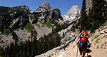
Customizable Directions


Copyright © 1997 - 2024 The Go Travel Sites. All Rights Reserved and.

Email Page Link

Complete the form below to email this page to a friend or family member's email. You can send yourself an email as well. Your email and your recipient's email will NOT be shared with anyone. See our full Privacy Policy for details.
:
:
:


:
Copy Yourself on the Email Yes No
:
:

1

Select a Free Visitor Guide below

2

Complete the form to receive your guides by mail

Below are the Free Visitor Guides for Sheridan. More Visitor Guides are available in Wyoming. Click here to view them all!

Visit Moffat County Visit Moffat County Visit Moffat County
Northwestern ColoradoWelcome to Colorado’s Great Northwest, Moffat County has nearly 2 million acres of public lands to explore. Experience places like Dinosaur National Monument, the Sand Wash Basin Wild Horse Management Area and free flowing rivers including the mighty Yampa, last of the wild ones!
Request this Free Visitor GuideRequested! You're all set! Complete the form below to receive your guides by mail.