


Basics
- Location:
- The Deschutes National Forest just outside of Bend
- Surface:
- Paved
- Length:
- 66 miles (106 km)
- Time:
- Three to five hours to visit this Byway.
- Season:
- Drivable year round
- Fees:
- There are fees associated with parking for more than a few hours near trailhead markers. Also, permits are required.
Description
The Cascade Lakes Scenic Byway takes an adventurous traveler through the heart of the Deschutes National Forest, mingling with countless lakes, ponds, and incredible mountain peaks. See everything from the Lava Cast Forest made of lava-molded trees, to the snowy slopes of Mt. Bachelor in the distance.
The byway starts in Bend which is in the very center of the state. Take HWY 46 from the border of the Deschutes National Forest all the way to HWY 58 where the byway ends.
Hiking is abundant at all levels of the sport as well as many water activities. Experience whitewater on the Deschutes River or calmly take a canoe onto one of hundreds of lakes. On land, Green Lakes Trailhead is one way to access the Three Sisters Wilderness area which contains miles of trails for a solitary wilderness experience. Along the drive, also be sure to check out Devil's Garden, a meadow bordered by several springs and full of lush grasses and flowers. It's a perfect place to take lunch as well as take a picture of the boulder in the meadow which is covered with Native American pictographs.
Points of Interest
Points of Interest Along The Way
Benham Falls (OR)
This attraction is actually misnamed, as it features rapids, not falls. Movies featuring this area include: The Indian Fighter, Rooster Cogburn, and Up the Creek.
To get to it, follow "Deschutes River Views" signs to the end of the road (from Lava Lands Visitor Center). Park at the picnic area and walk across the bridge and on the trail 1 mile downstream to view the spectacular scene of untamed rapids.
Crane Prairie Reservoir (OR)
Another view of Crane Prairie Reservoir can be seen on a side trip to the east shore, where commercial services are available.
Directions
The reservoir is located at the southern end of the byway next to the Osprey Observation Point. Southwest of Sunriver at Forest Service Road 40 about 55 miles from Bend.
Cultus Lake (OR)
The mixture of trees in this area offers a contrast to other areas along the Cascade Lakes Scenic Byway. Here you'll find ponderosa pine, douglas fir, white fir, white pine, sugar pine and spruce along the road into the lake area. This is one of the few places along the Byway where you'll find shallow sandy beaches.
Directions
From the Byway turn onto Forest Service Road 4635 and follow it west for 2 miles.
Deschutes National Forest (OR)
The Deschutes National Forest is a recreational haven, pure and simple: these 1.8 million acres include five wilderness areas (200,000 acres), six cool rivers, 157 lakes and reservoirs, approximately 1,400 miles of trails, and the unique landscape of Newberry National Volcanic Monument.
Popular activities in the national forest include hiking,fishing, rafting, kayaking, canoeing and camping. Other popular activities are mountain biking, cross-country skiing and snowmobiling, especially in the winter when the road closes due to snow.
Directions
This is a National Forest Service Byway, the forest surrounds the byway on both sides.
Deschutes River (OR)
The Deschutes River was named by fur traders of the Hudson Bay Company as "Riviere des chutes," meaning "river of falls." It has often been described as resembling a tree with nearly all of its branches on one side.
Because the lava underneath it acts as a giant sponge, the Deschutes River maintains a remarkably even flow even though it's fed by thousands of springs as it winds its way across the state,having started at Little Lava Lake. It eventually drops to a point of 150 feet above sea level as it reaches the Columbia River, 140 miles to the north.
This river plays an important role in irrigation, fish and wildlife habitat, and recreation in the form of fishing, whitewater rafting, tranquil float trips, and swimming.
A favorite thing to do here is float the Deschutes River from below Pringle Falls to just above Benham Falls, north of Sunriver Resort. Although its only about 29 miles "as the crow flies," the distance for the trip on the winding river is nearly double.
Directions
In the Deschutes National Forest
Devil's Garden (OR)
This meadow is bordered by several springs and covered with lush meadow grass, moss, blue lupines, and Indian paintbrush.
Pictographs on the face of a large dacite boulder evidence an ancient Indian trail and tell the story of a Warm Springs Indian brave that convinced a Klamath Indian maiden to return north with him. Later he and the warriors accompanying him were ambushed at this pass by a group of Klamath warriors who were led by a jealous rival. Unfortunately, the Indian art was vandalized in 1975, but some pictographs still remain.
Directions
West of Green Lakes Trailhead.
Drake Park (OR)
The northern leg of the byway begins in Bend. Make sure to spend some time exploring the charming downtown area which includes beautiful Drake Park before you go on to discover the rest of the byway.
Directions
Bend, Franklin Avenue and Riverside Blvd.
Dutchman Flat (OR)
Through nature's quirkiness, Dutchman Flat is an entirely different landscape than the rest of the byway and the area surrounding it: it's a small pumice desert which has not accumulated enough soil nutrients to sustain the growth of any plants except for a few extremely hearty plants such as pink-bloomed pussypaws and yellow-bloomed sulfur flowers.
Incidentally, parts of the movie How the West Was Won, starring Kirk Douglas and Robert Mitchum, were filmed in this area.
Directions
West of entrance to Mt. Bachelor
Fall River Fish Hatchery (OR)
Several thousand visitors come to the hatchery each year to seethe fish production activities and enjoy the hatchery's beautiful setting.
This hatchery is operated by the Oregon Department of Fish and Wildlife as part of the statewide fish propagation program and produces some 140 thousand legal-size rainbow trout annually.
The hatchery also works to stock Oregon's angling waters with many thousands of other kinds of smaller fish.
Directions
From LaPine State Park head east on State Recreation Rd. Take a left on Huntington Rd, then left on S. Century Rd (FS Rd 42). The hatchery is about 5 miles west on this road. It is located east of the byway, going to Sunriver and the Lava Cast Forest.
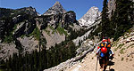
Green Lakes Trailhead (OR)
This trail is one of several access points into the Three Sisters Wilderness area.
The Three Sisters Wilderness Area is really worth hiking into(no motorized vehicles allowed) because its 200,000 acres are covered with 111 lakes and miles of solitudinous trails.The area is also important to get into because the largest glacier in Oregon (Collier Glacier) is located in North Sister.
On this trail and other trails in Three Sisters, wildlife is running everywhere and can be seen in abundance along the trails.Most common on these trails are deer, the Golden-Mantled ground squirrel, and the noisy Clark's Nutcracker.
Directions
On State Route 372 near Devils Lake, in the Three Sisters Wilderness, look for signs.