


Explore detailed info of Flaming Gorge National Recreation Area, or check out our expanded coverage of the Flaming Gorge National Recreation Area area, including Flaming Gorge National Recreation Area lodging, recreational activities, and more.
Contact Info
Box 279
Manila, UT 84046
Manila, UT 84046
- Phone:
- 435-784-3445
Basics
- Location:
- 36 miles north of Vernal
- Type:
- National Park
Description
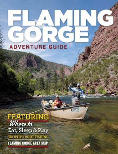
Big, beautiful Flaming Gorge Lake, enclosed by brightly colored canyon walls and set amidst hundreds of thousands of acres of forested hills, makes up the Flaming Gorge National Recreation Area. It is a wonderful setting in which to boat, fish, hike, bike or just stare.
Hours + Fees
Season:
May - September
Amenities
Amenities:
Campground
Modern Restrooms
Picnic Area(s)
Visitor Center
Modern Restrooms
Picnic Area(s)
Visitor Center
Details
Additional Details:
The main season runs from May to September, though a few facilities remain open all year for cross-country skiers, snowmobilers and ice fishers.
Map + Directions
Basic Directions
Flaming Gorge straddles the Utah/Wyoming border near the northeast corner of Utah. Though it reaches some 60 miles north to Green River, Wyoming, most of the activity and the most dramatic scenery are at its southern end in Utah.